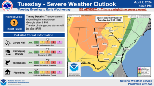
The National Weather Service in Peachtree City has issued a Flash Flood Watch for portions of central Georgia
northwest Georgia and west central Georgia
including the
following areas
Douglas .Carroll Chattooga Floyd Haralson Paulding Polk and Coweta.
* Through Wednesday afternoon
* A cold front will move southeast across the forecast area late
tonight through Wednesday. This front will bring another round
of locally heavy rainfall to much of north and central Georgia.
Rainfall amounts of one to two inches will be possible, with
locally higher amounts possible. Soils remain saturated and
several rivers, creeks and streams remain near or in flood, so
any additional rainfall will only create run off and exacerbate
ongoing flooding conditions.
* Flash flooding and minor flooding of larger creeks and rivers is
possible. This may close some roads and could flood homes and
businesses in flood-prone areas. Along larger creeks and rivers,
flooding could last for several days.
Recommended actions
A Flash Flood Watch means that conditions may develop that lead
to flash flooding. Flash flooding is a very dangerous situation.
You should monitor later forecasts and be prepared to take action
should Flash Flood Warnings be issued.


