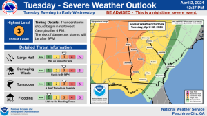
According to the Carroll County EMA and the National Weather Service in Peachtree City there is the potential for severe weather in our area throughout the day on Thursday.
- The main impacts are:
- Tornadoes (Strong, Long Track Tornadoes are possible)
- Damaging Winds (60-70 mph wind gusts possible)
- Heavy Rain (localized flooding possible)
- Hail (Greater than 1 diameter)
- The higher risk area for this system is central Alabama and along and south of the I-20 corridor in Georgia. Specifically the Cleburne and Randolph County Alabama area and areas along and south of the I-20 corridor in Georgia are within the Enhanced Risk (Level 3 out of 5). This includes Carroll, Haralson and Heard counties in Georgia. The area north of Haralson and Carroll counties are within the Slight Risk (Level 2 out of 5) for Severe Weather with this system. Along and south of I-20 is the areas of greatest severe risk. All of the counties in our area are included in the area designated to possibly have a significant tornado event. A few strong long track tornadoes are possible in this area. These same areas are also within the area to possibly receive strong straight line winds (60-70 mph) and hail greater than 1 inch in diameter.
- Two rounds of thunderstorms are possible.
-
- The first round of strong to severe thunderstorms with the potential to produce widespread damaging winds expected in the morning and early afternoon.
- The second round of severe thunderstorms capable of producing tornadoes, hail and damaging winds are expected in the late afternoon and Thursday night.
You can download additional geographical information here: 2020-04-22-Slides-for-Email