per #CarrollCountyGA EMA Director Tim Padgett:
The National Weather Service held a Special Weather Briefing this afternoon to provide an update on the forecast Severe Weather Event for our area Sunday afternoon, Sunday evening and overnight Sunday night.
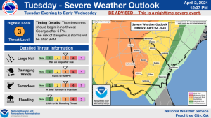
Presently the forecast indicates multiple rounds of storms Sunday with possibly one round Sunday morning, a more intense round later Sunday afternoon and the most dangerous round Sunday night into Monday morning. The timing on the most severe round is currently forecast for East Alabama between 1900 and 2200 Sunday night and for West Georgia 2100 to Midnight Sunday night.
The main impacts from this system are Tornadoes (strong, long track tornadoes are possible), Damaging Winds, Hail and Heavy rain. The forecast currently places us in a Enhanced Risk for Severe Weather (Level 2 out of 5) with a Moderate Risk (Level 3 out of 5) over Eastern Alabama which could also include West Georgia with forecast updates as we get closer to the event.
This Severe Weather outbreak has the potential to be in the top 5 for most significant severe weather events in the last 10 years. The most recent moderate risk in our area was on April 5, 2017.
Please see the attached slides for additional graphical information.
We will continue to monitor the situation and provide addition email updates as information is received.
Please have a device for or getting Severe Weather Warning at night