Wednesday, September 28, 2022 – 5:13pm
This is the 5:00pm Public Advisory Discussion and Outlook from the National Hurricane Center (NHC) in reference to Hurricane Ian.
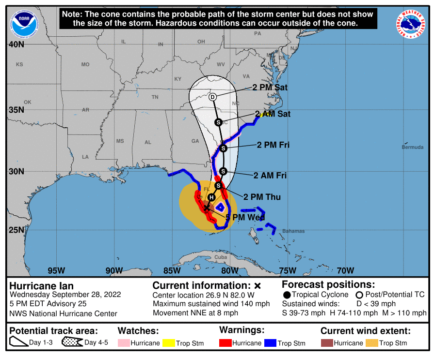
At 500 PM EDT (2100 UTC), the eye of Hurricane Ian was located
near latitude 26.9 North, longitude 82.0 West. Ian is moving toward
the north-northeast near 8 mph (13 km/h). On the forecast track,
the center of Ian is expected to move across central Florida
tonight and Thursday morning and emerge over the western Atlantic by
late Thursday.  Ian is forecast to turn northward on Friday and
approach the northeastern Florida coast, Georgia and South Carolina
coasts late Friday.

Maximum sustained winds have decreased to near 140 mph (220 km/h)
with higher gusts.  Ian is a category 4 hurricane on the
Saffir-Simpson Hurricane Wind Scale.  Further weakening is
expected for the next day or so, but Ian could be near hurricane
strength when it moves over the Florida East coast tomorrow, and
when it approaches the northeastern Florida, Georgia and South
Carolina coasts late Friday.

Hurricane-force winds extend outward up to 50 miles (85 km) from the
center and tropical-storm-force winds extend outward up to 175 miles
(280 km).  A WeatherFlow station in Grove City recently reported
sustained winds of 95 mph (153 km/h) and a wind gust of 128 mph
(208 km/h).  A University of Florida Coastal Monitoring
Program wind tower recently reported sustained winds of 89 mph
(143 km/h) with a gust to 114 mph (183 km/h).

The estimated minimum central pressure is 945 mb (27.91 inches).
Wednesday, September 28, 2022 – 1:37pm
This is the 09/28 update from the National Weather Service (NWS) in reference to Hurricane Ian.
Ian is a powerful major (Cat 4) hurricane and is making landfall along the southwest Florida coast between Sarasota and Cape Coral. Confidence is increasing in the latest forecast track/trends. The forecast track has moved further east which has significantly reduced the impacts to East Alabama and West Georgia.
Wind – Based on the current track, our area is projected to not have any Tropical Storm Force Winds. There is a pressure gradient setting up with the storm which may produce some winds gusts in our area between 20-30 mph, but still below Tropical Storm levels.
Rain – Based on the current forecast track, the heaviest rain is being pushed further east. Our area could see 0.5 to 1 inch of rain but there is a chance that our area will not see any rain at all with this system.
Travel – For those planning travel this weekend, conditions will deteriorate rapidly as you travel east and specifically southeast of the Atlanta area. Those areas could have heavy rain and sustained winds of 20-30 mph with much higher wind gusts. Use caution when planning travel this weekend.
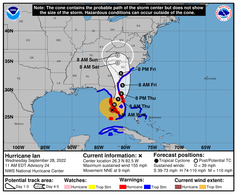
Wednesday, September 28, 2022 – 6:00am
Latest on IAN from GNN Meteorologist John Wetherbee:
75 miles WSW of Naples with 140 mph winds, moving NNE at 10 mph with pressure at 942 mbs, rain and wind already sweeping across South Florida, 2nd official landfall later today. And the new 0500 Advisory calls for a 3rd landfall in Savannah on Friday.
Life-threatening storm surge is expected along the Florida west coast and the Lower Florida Keys where a storm surge warning is in effect, with the highest risk from Naples to the Sarasota region.
Residents in these areas should listen to advice given by local officials and follow any evacuation orders for your area.
Hurricane-force winds are expected in the hurricane warning area in southwest and west-central Florida beginning Wednesday morning with tropical storm conditions expected overnight.
Catastrophic wind damage is expected near the core of Ian when it moves onshore.
Heavy rainfall will spread across the Florida peninsula through Thursday and reach portions of the Southeast later this week and this weekend. Widespread, life-threatening catastrophic flooding is expected across portions of central Florida with considerable flooding in southern Florida, northern Florida, southeastern Georgia and coastal South Carolina. Widespread, prolonged major and record river flooding expected across central Florida.
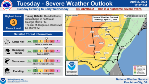
Tuesday, September 27, 2022 – 12:02pm
From Carroll County EMA Director Tim Padgett and the National Weather Service, Peachtree City, GA:
The National Weather Service held a Special Weather Briefing today in reference to Hurricane Ian.
Ian is now a major hurricane (Cat 3) and is expected to make landfall in Florida as a Major Hurricane late Wednesday. The latest forecast track from the National Hurricane Center (NHC) is slightly farther south at landfall, then more east and faster.
There continues to be high uncertainty in the track beyond Wednesday. Small shifts east or west in the track can result in significant differences in potential impacts for East Alabama and West Georgia.
Wind – Based on the current track, our area is projected to have wind gusts of 30-40 mph over a prolonged period of time as the storm moves through the state.
Rain – Based on the current forecast track our area could see 2-3 inches of rain Thursday – Sunday. Rainfall amounts could be higher if the track of the storm moves farther west. The highest rainfall amounts are expected to occur during the 24 hours period on Friday.
The forecast track will become more refined as we move closer to landfall on Wednesday. Additional updates will be provided by the NWS each day.
For more information, refer to the NWS Special Weather Briefing recording from YouTube below or click here for the PDF version of the slides.
Tuesday, September 27, 2022 – 10:53am
From Georgia News Network (GNN) Meteorologist John Wetherbee:
Forecast track has shifted east again, now Florida landfall near Tampa as a Major Hurricane overnight Wednesday night, and slowly tracking up the center of Florida into Georgia. Latest NHC forecast here. Complete update at 1100.
Ian’s impact on Georgia will be covered in GNN weather updates throughout the day.
Tuesday, September 27, 2022 – 10:36am
The Georgia High School Association (GHSA) has announced that the following local high school football game(s) have been rescheduled due to Hurricane Ian:
- Gordon Central @ Haralson County – moved to Thursday, September 29, 7:30pm
(broadcast will remain on WKNG King Country)
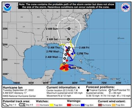
Monday, September 26, 2022 – 9:18pm
Below is the 8:00pm ET intermediate advisory from the National Hurricane Center:
At 800 PM EDT (0000 UTC), the center of Hurricane Ian was located
near latitude 20.8 North, longitude 83.3 West.  Ian is moving toward
the north-northwest near 13 mph (20 km/h).  A turn toward the north
with a slightly slower forward speed is expected on Tuesday. A turn
toward the north-northeast with a further reduction in forward speed
is forecast on Wednesday.  On the forecast track, the center of Ian
is expected to move near or over western Cuba tonight and early
Tuesday.  Ian will then emerge over the southeastern Gulf of Mexico
on Tuesday, pass west of the Florida Keys late Tuesday, and approach
the west coast of Florida on Wednesday into Thursday.

Maximum sustained winds are near 100 mph (155 km/h) with higher
gusts.  Rapid strengthening is expected during the next day or so,
and Ian is forecast to become a major hurricane tonight or early
Tuesday when it is near western Cuba, and remain a major hurricane
over the southeastern Gulf of Mexico on Wednesday.

Hurricane-force winds extend outward up to 35 miles (55 km) from
the center and tropical-storm-force winds extend outward up to 115
miles (185 km).

The minimum central pressure estimated from Air Force Hurricane
Hunter aircraft observations is 965 mb (28.50 inches).
Monday, September 26, 2022 – 2:15pm
From Carroll County EMA Director Tim Padgett and the National Weather Service, Peachtree City, GA:
Then National Weather Service held a Special Weather Briefing today in reference to Hurricane Ian.
Ian is now a Hurricane and is forecast to rapidly intensify into a major hurricane (Cat 3+) in the next 24-36 hours. The latest forecast track from the National Hurricane Center (NHC) is slightly right/east of the previous forecast.
There is high uncertainty in the track beyond 48-72 hours (Wed/Thurs). Small shifts east or west in the track can result in significant differences in potential impacts for East Alabama and West Georgia.
Wind – Based on the current forecast track, we could see Tropical-Storm-Force Winds (>40 mph) Thursday morning through Friday.
Rain – Based on the current forecast track our area could see 3+ inches of rain Thursday – Sunday. Rainfall amounts could be higher if the track of the storm moves farther west.
The forecast track will become more refined as we move closer to landfall later this week. Additional updates will be provided by the NWS each day.
For more information, refer to the NWS Special Weather Briefing recording from YouTube below or click here for the PDF version of the slides.