The National Weather Service (NWS) held a Special Weather Briefing today in reference to the potential for Severe Weather to occur in our area this afternoon and evening and overnight tonight.
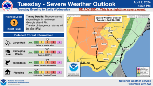
The Storm Prediction Center (SPC) has placed the northern 1/3 of Carroll County, all of Haralson County and the State of Alabama north of I-20 in a Moderate Risk for severe weather which means widespread severe storms are likely.
The SPC has placed the remainder of Carroll County south to Macon and west into Alabama in an Enhanced Risk for severe weather which means numerous severe storms possible.
All of our area is within the area noted as having an increased risk for tornadoes this evening and also large hail in excess of 2 inches in diameter.
Round 1 Between 4:00 pm and 8:00 pm (ET) with Hail and Damaging Winds being the main threat. The Tornado threat increases with time into the evening any time after 6:00 pm
Round 2 Between 10:00 pm and Midnight (ET) with the primary threat being Large Hail, Damaging Winds and Tornadoes.
Please monitor this situation and this afternoon and evening and pay special attention to the following terms if you hear them from the National Weather Service or Media Outlets:
PDS Watch = Particularly Dangerous Situation. (Used with strong to violent tornadoes are likely somewhere in the watch)
Radar Observed Tornado = Radar is able to see debris sometime within a tornado when the tornado is on the ground. This term is used when that radar signature is seen without confirmation from someone actually seeing the Tornado on the ground.
Tornado Emergency = The NWS is certain that a strong to Violent tornado IS on the ground.